|
|
Post by jackmatt on Mar 11, 2016 6:58:07 GMT
Hi all,
As the title says Towns, City's or Village. My question is has anyone out their ever crafted a map of one all all these? If so how did you do it, if not how would you???
Jackmatt.
|
|
pepebe
Paint Manipulator
 
Posts: 187 
|
Post by pepebe on Mar 11, 2016 8:10:46 GMT
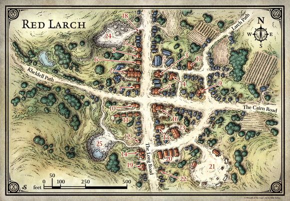
Something that is very easy to do and is not only nice to look at but also very useful on the table are 2.5d topographic maps (c). I did this with a Red Larch map for Princess of the Apocalypse. The village is located at the crossroads of two important trade roads. The hills in the West are about 50 yards higher than the street level in the city center. In the north-east it the area is only about 20 feet higher. There is also a small hill in the south-east that rises to about 30 feet. This is the original map by Mike Schley  Source: mikeschley
How it was done:- I resized the map to A3 and then I split it into four parts and printed each one in A4. I did this 3 or four times to have enough material for the elevation levels. (In hindsight, a single print could also have done the job).
- Then I glued the complete map on a big piece of double layer corrugated cardboard.
- Next I cut out the pieces that represented the first elevation level and glued them on 3mm thick carboard (the gray stuff found on the back of drawing paper).
- For every 10 feet I cut out an elevation level and then I glued all pieces on my map.
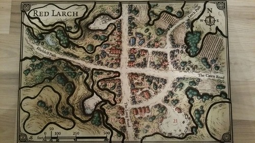
- I used a black marker to hide the edges of the cardboard and to emphasize the elevation lines.
This was useful for several reasons:- The map gave the village more importance. It became an actual place with hills, buildings, streets, fences, walls and gardens rather than a piece of paper.
- It was hard to forget about the map. It screamed to be used and it was consulted very often during game play.
- Players decided to go for a walk "to have a top-down view" of the village.
- At a size of A3, the map could be used for strategic movement. We used small measure sticks for strategic movement of troops and characters. We used small beads for this, but I think pins would also be fine.
I'll upload a photo of the finished map this weekend. Cheers, patrick |
|
|
|
Post by jackmatt on Mar 11, 2016 10:18:49 GMT
Thankyou Patrick, looking forward to seeing your photos.
Jackmatt.
|
|
|
|
Post by DnDPaladin on Mar 11, 2016 20:29:40 GMT
depends on what you are asking.
the maps are cool.
the 3D maps are also cool, i've seen a few.
if it comes to tiles and say battlegrounds in the city. then you could use DM scotty tilescape fronts to simulate housing and the likes. works really well.
|
|
|
|
Post by jackmatt on Mar 12, 2016 15:17:19 GMT
DnDPaladin, I do like the idea of using Scotty's building fronts for miniature scale town maps, but I was thinking more along the lines of what pepede was describing. I remember when I was a GW fan and Mordhime was releases, white dwarf gad a map one of the design team had made.
Jackmatt.
|
|
|
|
Post by DnDPaladin on Mar 12, 2016 19:19:52 GMT
dont remember who it was, i'd have to search the forum for it. but someone was making maps with monopoly houses and using push pins with names on it to simulate players movement on that map. it was a nice 3D map and he could even remove some houses from it if they ever got destroyed or anything.
|
|
|
|
Post by curufin on Mar 12, 2016 22:53:15 GMT
dont remember who it was, i'd have to search the forum for it. but someone was making maps with monopoly houses and using push pins with names on it to simulate players movement on that map. it was a nice 3D map and he could even remove some houses from it if they ever got destroyed or anything. I believe this is the one you are talking about link |
|
|
|
Post by DnDPaladin on Mar 13, 2016 3:46:17 GMT
Yes thats the one, thanks !
|
|
|
|
Post by jackmatt on Mar 13, 2016 9:42:06 GMT
Curufin, thankyou that is excellent what I was thinking of, anyone out there done something similar??? Share pictures please.
Jackmatt.
|
|
pepebe
Paint Manipulator
 
Posts: 187 
|
Post by pepebe on Mar 16, 2016 0:14:55 GMT
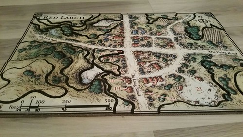
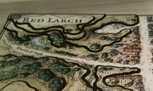
Thankyou Patrick, looking forward to seeing your photos. Jackmatt. I don't have it at home, but I asked one of my players to make some photos.  Top down view  View from the side  Top left corner I used 3mm cardstock (the gray stuff) from a college block to build up the elevation levels. To emphasize the elevation lines I used a black marker. I used the marker for two reasons. First, it helped to hide a few imperfections that I didn't like. Second, it helps a lot to understand the map if you are looking at it from a distance (2m). For measuring distances on the map we used a custom measuring stick. If I find it, I'll post another photo. |
|
|
|
Post by tauster on Mar 16, 2016 7:06:12 GMT
See here for an old and unfnished attempt of yours truly to make a 3D map of an asteroid town...  |
|